|
|
|
|
|
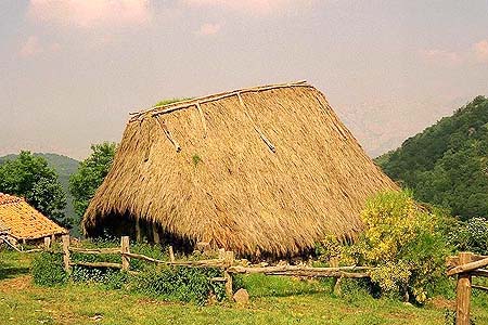
Asturies is located in the far Northwest of the Iberian peninsula, has an area of 10,565 km2: From a imaginary triangle, the northern side would be the Bay of Biscay, running along parallel 43º 36'. According to orography Asturies can be split in three areas: Mountain, mainly near the southern borderline, inner valleys and plains, and the coastal fringe. A stunning coastline with high cliffs and sandy bays gives you a choice of rocky cove or sandy beach, fishing port -Llanes, Tazones, Cuideiru, or resort Ribeseya. Explore the magnificent Los Picos d'Europa, among the most rugged and dramatic mountains in Europe -walk the Cares Gorge, take the twisty drive to the little lakes of L'Arcina and Enol, strike out for the El Picu Urriellu, eat the green cheeses of Cabrales. Discover
Asturies' rich cultural heritage, Cuadonga, the
mountain pilgrimage centre where Asturians claim
the birth of their country took place, Uvieo with
its Gothic cathedral and Pre-Romanesque churches,
the prehistoric caves of El Pozu'l Ramu, the museum
of "Indianos" in Colombres... Enjoy local markets, little restaurants, seaside restaurants and cafés; eat seafood, bean stews (fabada), try the local cider and admire the way your barman pours it into the glass. Uvieo, home to over 200,000 inhabitants, is the administrative, commercial and cultural centre of Asturies. Just 21 miles from the coast, Uvieo is the gateway to great scenery, skiing, and beaches. It is also a "university town," as it has been for nearly four centuries, home to the University of Uvieo, with over 45,000 students and 1,600 faculty members.
|
|||
|
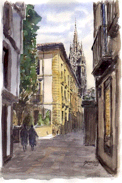
Uvieo
The
Cathedral of St. Salvador was restored in the
twelfth century by Archbishop Don Pelayo, the
chronicler. Bishop Fernando Alfonso (1296-1301)
undertook another restoration of the
chapter-house, and his successor, Fernando Alvarez
(1302-1321), began the cloister. At the end of the
thirteenth century Gutierre de Toledo began the
new Gothic basilica, the principal chapel bearing
his arms, although
| |||
|
El
Monte Muniel.los In this is well preserved forest, little evidence of human presence is visible. At the bottom of bigger valleys, according to legend, there are as many of these as days in a year
Although trees dominate the landscape, over 400 species of vascular plants
are present in the Reserve, some included in the Catalogue of Threatened
Species from the Flora of Asturies. | |||
| Xixón Xixón
is set in the middle of the Asturian coast,
it is the largest city in Asturies with nearly 300,000 inhabitants
and is called the
capital of the Costa Verde (Green
Coast). This easy going
city was completely rebuilt after its
destruction in the Spanish Civil War. Nowadays
is the main tourist centre, but it is also an industrial
city, with industrial and
leisure ports, beaches, an intense cultural life
and important museums as well. Its
origins date back in antiquity due to its
privileged situation by the coast
overviewed from La Talaya,
this ideal peninsula was protected by a
wall -currently under archaeological
investigation-, but little is known of its
history before the Romans. Once passed the industrial outskirts, the city has quite a breezy, open feel about it, with a grid of streets backing onto the sands of Playa de San Llorienzo, a surprisingly unpolluted beach. The old part of town, Cimavilla, occupies a headland west of the beach- a visit can begin from Xove-Llanos square where the Palace of Valdés (17th Century) is placed over the Roman bath (1st century). In the same plaza the Museum of Xove-Llanos (16th century), subsequently restored, containing personal memorabilia, paintings and sculptures. Adjacent to the building Los Remedios chapel. In the plaza of Remedies, the House of the Nava family (17th century). To complete the cultural walk, a visit to the remaining museums of Xixón: Ethnographic Museum of Asturies enclosed in the Ferial Ground, next to the Bagpipe Museum and finally the Evaristo Valle Museum situated in Somió surrounded by splendid gardens. These and more make a visit to Xixón an unforgettable remembrance that invites to return..
| |||
|
| |||
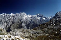
| Los
Picos d'Europa Although
Los
Picos are not the highest mountains in Spain, they are the favourite of many
walkers, trekkers and climbers. The range is a miniature master-piece: a
mere forty kilometres across in either direction, shoehorned in between
three great river gorges, and straddling between Asturies, Cantabria and
León. For Asturians this is a symbol of their national identity.
Here
lies the most spectacular area of mountains in
Asturias, the Los Picos d'Europa, at only
20 km from the coast. National Park since 1995,
they are a privileged place where visitors can
find the best conditions for the practice of
active tourism. The
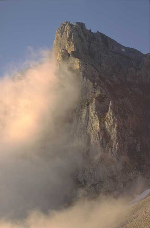
East face of the El Picu Urriellu, is a 300 m wall
(1000 ft.) in the heart of Los Picos, providing an
emblematic symbol for Asturians.
Walks in the Los Picos d'Europa area amazingly diverse, considering the size of the region, and they include trails for all levels of activity -from a casual morning walk to two-and-three-day treks.- It was more of a sense of something large and boulder-shaped on the edge of a tract of Pyrenean oak and on the edge of my vision. It lasted a split-second and the more I think about it, the more I think it could have been my imagination - or wishful thinking. I continued to sit, with the sun burning off the last vestige of early morning haze, and strained my eyes and ears for confirmation of a large carnivore in the vicinity. But the only movement to catch my eye was that of a myriad of jewel-coloured butterflies rippling across the meadow and the only sound was that of sublime silence. In
Los Picos d'Europa in northern Spain, you can find true wilderness. Small and compact this little tangle of limestone peaks may be - a scaled
down version of the Alps - but Los Picos are more than a match in grandeur
and scenic drama. They help to make up the Cordalera Cantábrica,
a mountain range which extends right across the north of the country from
the Pyrenees, almost to Portugal, contributing to the reason why Spain is
the second-most mountainous country in Europe, next to Switzerland.
The limestone massif of the Los Picos is bisected with spectacular gorges and steep-sided valleys and clothed in forests of oak, evergreen, ash, lime and beech. Wonderfully rich hay meadows, untouched by pesticides and fertilizers and mostly cut by hand, claim status of the richest in Europe and provide a spectacular floral display in spring - as it was on this day. It is in spring that the Spanish brown bear emerges from a winter torpor to feed in meadows such as this, digging up roots and tubers to built up fat reserves diminished by lack of food and (in the case of females) much suckling! Brown bears were once widespread throughout the Iberian Peninsular but now their only stronghold lies in two widely separated nuclei in the Cordalera Cantábrica: from the Asturian side (National Hunting Reserves of Sumiedu and Degaña and the Integral Biological Reserve of Muniellos), and the mountains of León, Palencia and Cantabria. The Asturian population is the strongest, comprising three-quarters of the total number of Spanish bears with between 120 and 164 individuals, but with numbers dropping all the time. In fact, environmental groups fear their numbers fail to exceed eighty individuals! Fauna and flora Although the brown bear (Ursus arctos) has been legally protected since 1973, it faces continual threats from trophy hunters and angry farmers despite that fact that these farmers are compensated by the government and conservation societies for any livestock lost to rogue bears. A secondary threat to the Spanish bear comes with its willingness to eat carrion. Many have died when they have been attracted to poisoned carcasses largely intended for wolves. And so to the beleaguered Iberian wolf (Canis lupus), a creature the farmers have no difficulty seeing but which tourists and conservationists rarely do! And, yet again, it is the farmers who dont want them there and do their utmost to wipe the population out. The Iberian wolf exists in small populations scattered around the peninsula: here in the Los Picos, Galicia and León, along the Spanish-Portuguese border, around Estremadura and also in the Sierra Morena in northern Andalusia. Numbers are rather more healthy than that of the bear at 1500 individuals but, although the wolf is fully protected in Portugal, it is classed as a game animal throughout Spain. Although this category allows some protection, local administrations handle nature conservation on an individual basis and any protection afforded is very liberal! However, I was pleased to learn that Andalusia offers complete protection for its wolves where they occupy uninhabited tracts of natural habitat and feed on red deer, but throughout the rest of the country wolves are shot and poisoned. Razor crags cut into the skyline hiding waterfalls and lakes, arrets, screes, plummeting cliffs with tiny red-roofed hamlets snuggled in the foothills where little patchwork goats graze alongside wild Asturian horses (or asturcones). Once again, poisoned bait lain down for wolves have caused problems for the griffon vultures (Gyps fulvus) but their numbers here represent the majority of Europes population. Despite their gruesome reputation, the world needs vultures to keep disease at bay - sanitising natural habitat by eating flesh that, if left, would cause contamination of the countryside. The predators of the Los Picos d'Europa (indeed, the whole of Spain) are hanging on by their clawtips; from wild cat to Iberian Lynx (Lynx pardinus), raptors, wolves and bears - rich and rare - and it would be devastating to see these beasts classed as "extinct in Spain". There are three Massifs in Los Picos as shown on the map below. The Western Massif (Les Peñes Santes) is to the west of the Ríu Cares. The Central Massif (Los Urrieles) is between the Cares Gorge and the Ríu Tielvi. The Eastern Massif (Andra) is to the East of the Tielvi River. The Eastern Massif is the area to the south of Sotres and Tresviso. Most of the caves drain into a river resurgence cave called Cueva l'Agua near Tresviso and at an altitude of 454 metres, and several kilometres long rises nearly 400 metres in altitude. There are many more caves marked on the sketch maps and some have just a described location- anyone feel like walking around the mountainsides for a few weeks with a GPS system? | |||
|
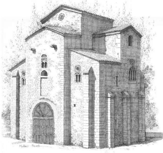
 and protected by the Cantabrian Mountains,
Asturies remained a haven for much of Iberian
culture for centuries, developing the unique
Asturian (Pre-Romanesque) architectural style that
crystallized the values of the emerging Christian
society much earlier than in the rest of Europe.
and protected by the Cantabrian Mountains,
Asturies remained a haven for much of Iberian
culture for centuries, developing the unique
Asturian (Pre-Romanesque) architectural style that
crystallized the values of the emerging Christian
society much earlier than in the rest of Europe.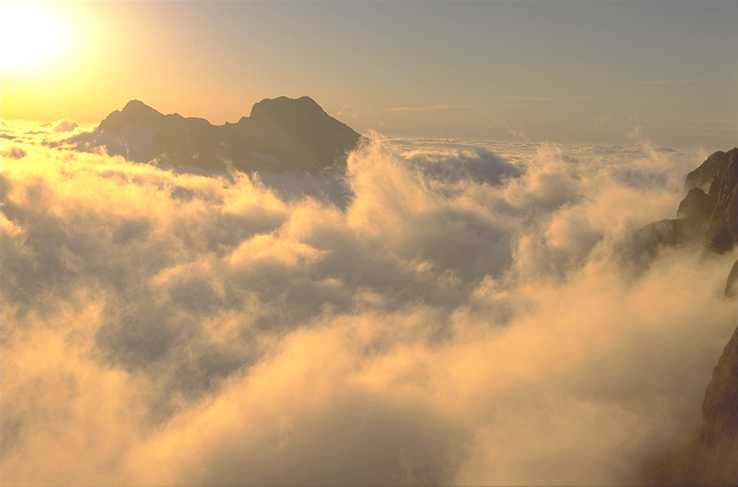 The
climate is Atlantic with mild temperatures and
abundant rainfall all year round which favours the
existence of varied and rich vegetation (such as
the Oakwood of Muniellos and the Natural Park of
Cuadonga).
The
climate is Atlantic with mild temperatures and
abundant rainfall all year round which favours the
existence of varied and rich vegetation (such as
the Oakwood of Muniellos and the Natural Park of
Cuadonga). 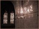
 The
city of Uvieo is situated in central Asturies at the foot of Mount El Naranco combining a prosperous urban
area with monumental heritage witness of a ast rich in history. The city was founded by King
Fruela I (756-68). In AD 760 Abbot Fromistanus and
his nephew Maximus built a monastery there and
dedicated a church to St. Vincent;
Fruela had houses built and the basilica of S.
Salvador. His son, King Alfonso II, the Chaste, made
Uvieo his capital and restored the Church of St. Salvador. A number of bishops, expelled from their
sees by the Saracens, were gathered at the city,
where they held two councils.
The
city of Uvieo is situated in central Asturies at the foot of Mount El Naranco combining a prosperous urban
area with monumental heritage witness of a ast rich in history. The city was founded by King
Fruela I (756-68). In AD 760 Abbot Fromistanus and
his nephew Maximus built a monastery there and
dedicated a church to St. Vincent;
Fruela had houses built and the basilica of S.
Salvador. His son, King Alfonso II, the Chaste, made
Uvieo his capital and restored the Church of St. Salvador. A number of bishops, expelled from their
sees by the Saracens, were gathered at the city,
where they held two councils.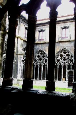 it was completed by his successor
Guillén. Diego Ramirez de Guzmán (1421-1441) built
the two chapels of the south transept (now
replaced by the sacristy), the old entrance to the
church, and the gallery of the cloister adjoining
the chapter-house. Alonzo de Palenzuela
(1470-1485)
completed the other part of the transept. Juan
Arias (1487-1497) left his cognizance, the
fleur-de-lys
and four scallops, on the nave. Juan Daza
(1497-1503) erected the grille of the choir;
Valerano (1508-12) added the stained-glass
windows. Diego de Muros, had the crestings of the
porch wrought by Pedro de Bruyeres and Xuan de
Cerecedo Senior, while Giralte and Balmaseda
completed the carving of the precious altarpiece in
the time of Francisco de Mendoza (1525-1528). Cristóbal
de Rojas (1546-56) affixed his coat-of-arms to the
completed tower, with its octagonal pyramid, one
of the marvels of Gothic architecture. The chief
feature of the cathedral is the "Camara
Santa", with its venerable relics. Bishop Don
Pelayo relates that a coffer made by the disciples
of the Apostles, and containing the most precious
relics of the Holy City, was taken from Jerusalem
to Africa, and after several translations was
finally deposited at Uvieo by King Alfonso II.
it was completed by his successor
Guillén. Diego Ramirez de Guzmán (1421-1441) built
the two chapels of the south transept (now
replaced by the sacristy), the old entrance to the
church, and the gallery of the cloister adjoining
the chapter-house. Alonzo de Palenzuela
(1470-1485)
completed the other part of the transept. Juan
Arias (1487-1497) left his cognizance, the
fleur-de-lys
and four scallops, on the nave. Juan Daza
(1497-1503) erected the grille of the choir;
Valerano (1508-12) added the stained-glass
windows. Diego de Muros, had the crestings of the
porch wrought by Pedro de Bruyeres and Xuan de
Cerecedo Senior, while Giralte and Balmaseda
completed the carving of the precious altarpiece in
the time of Francisco de Mendoza (1525-1528). Cristóbal
de Rojas (1546-56) affixed his coat-of-arms to the
completed tower, with its octagonal pyramid, one
of the marvels of Gothic architecture. The chief
feature of the cathedral is the "Camara
Santa", with its venerable relics. Bishop Don
Pelayo relates that a coffer made by the disciples
of the Apostles, and containing the most precious
relics of the Holy City, was taken from Jerusalem
to Africa, and after several translations was
finally deposited at Uvieo by King Alfonso II.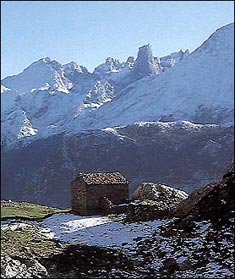 Where
wild habitat remains in the mountains, it is dominated by oak groves growing
alongside ash, beech, birch, hazel, pine, and holly trees.
Where
wild habitat remains in the mountains, it is dominated by oak groves growing
alongside ash, beech, birch, hazel, pine, and holly trees. 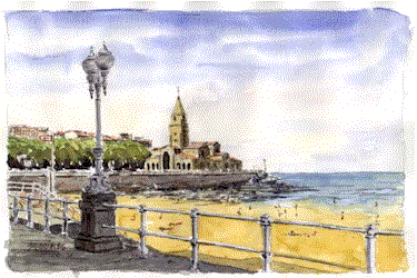
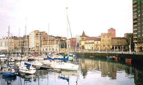 Descending from Oscar
Olavarría Street we come out of Cimavilla arriving to the Marina. The
Palace of Revilla-Gigedo (today the Centre International of Arts) dates from the 18th century and was recently restored
(built in an splendid mix of neo-Baroque and neo-Renaissance styles). Leaned to the palace, the Church of Saint John the Baptist "La Colexata"
whose construction finalised in 1702. A statue of King Pelayo can be seen in
the plaza. Nearby, the Barjola Museum of Contemporary Art finds accommodation
in the Palace and Chapel of the Trinity (17th century).
Descending from Oscar
Olavarría Street we come out of Cimavilla arriving to the Marina. The
Palace of Revilla-Gigedo (today the Centre International of Arts) dates from the 18th century and was recently restored
(built in an splendid mix of neo-Baroque and neo-Renaissance styles). Leaned to the palace, the Church of Saint John the Baptist "La Colexata"
whose construction finalised in 1702. A statue of King Pelayo can be seen in
the plaza. Nearby, the Barjola Museum of Contemporary Art finds accommodation
in the Palace and Chapel of the Trinity (17th century).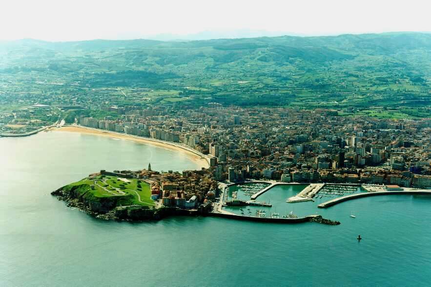
 Mountains
start by El Puertu Tarna, where the river Nalón
is born, going eastwards through El Puirtu Braña and
El Puerto Payares,
to end by L'Altu Ventana and Sumiedu, where
a Natural Park was established in 1988, covering
the south border of Asturies.
Mountains
start by El Puertu Tarna, where the river Nalón
is born, going eastwards through El Puirtu Braña and
El Puerto Payares,
to end by L'Altu Ventana and Sumiedu, where
a Natural Park was established in 1988, covering
the south border of Asturies.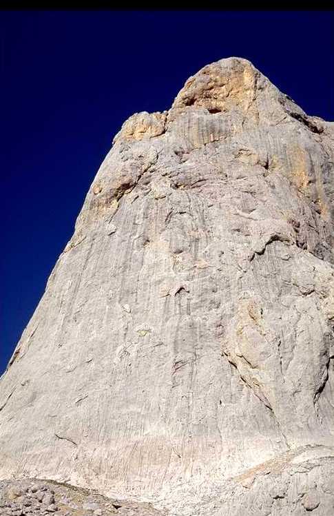
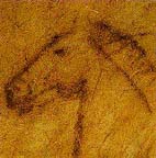 caves belonging to the Upper Palaeolithic with
remains of Art Parietal, or Cave Painting; the
most relevant ones are in Candamu, El Pozu'l Ramu, El Pindal
and El Buxu.
caves belonging to the Upper Palaeolithic with
remains of Art Parietal, or Cave Painting; the
most relevant ones are in Candamu, El Pozu'l Ramu, El Pindal
and El Buxu.